
South Bay & Regional Attractions
The South San Francisco Bay Area region has many more attractions to offer beyond the few that the Planning Committee was able to incorporate into the official agenda. Whether you’re looking for options to entertain yourself during open slots in the schedule or to find activities for the days before or after the week of the meeting, there are many interesting sights to explore nearby. Here are a few options to consider:
Welcome to California
The Planning Committee recognizes many meeting attendees travel a great distance to join us. Wherever you call home, California offers some amazing and unique-in-the-world attractions to all visitors. The following pages offer a variety of suggestions for day and overnight trips from San Jose, starting with local attractions we could not fit into the itinerary and branching out into more distant options. Wherever your adventures take you, we wish you safe and enjoyable travels as you explore our great state!
Winchester Mystery House – 525 S Winchester Blvd, San Jose (4.7 Miles, 10 min drive)
The Winchester Mystery House offers daily guided tours of a sprawling 160-room Victorian mansion once owned by the heiress to the Winchester Repeating Rifle Company, Sarah Winchester. Said to be haunted by the ghosts of those killed with the rifles her family manufactured, Sarah oversaw continuous construction and expansion of a once-tiny San Jose farmhouse for decades until she passed away.
https://winchestermysteryhouse.com/
Rosicrucian Egyptian Museum – 1660 Park Ave, San Jose (2.1 Miles, 7 min drive)
Members of the Rosicrucian Order in San Jose maintain and operate a complex north of downtown that includes a research library, ornate garden, and an Egyptian Artifact Museum. The museum is open Fridays and weekends and boasts the largest collection of authentic Egyptian artifacts on display in Western North America.
https://www.egyptianmuseum.org/
Mission San Jose – 43300 Mission Blvd, Fremont (20.4 Miles, 25 min drive)
Founded in 1797, Mission San Jose is the 14th of 21 missions built by Spanish missionaries during the colonial occupation of Alta California. The property features the original mission building, a rose garden, cemetery, and museum. For those wanting sweeping views of the surrounding area, the nearby Mission Peak Trailhead offers a strenuous 6-mile loop hike to a well-trafficked overlook.
https://www.saintjosephmsj.org/mission/
Shopping Options – 377 Santana Row, San Jose (4.8 Miles, 11 min drive)
San Jose has two primary options for retail shopping: Santana Row (home to very upscale restaurants, bars, and designer stores) and the Westfield Valley Fair Shopping Center. They sit across Stevens Creek Blvd from each other at the intersection with Winchester Blvd.
https://santanarow.com/ https://www.westfield.com/en/united-states/valleyfair
Filoli Historic House and Garden – 86 Cañada Rd, Woodside (29.7 Miles, 31 min drive)
Filoli features a 54,000 sf Georgian revival-style mansion built in 1917 on 16 acres of English Renaissance Gardens. The property offers daily general admission tickets for self-guided exploration of the gardens and house. The nearby Pulgas Water Temple marks the location where water from the Sierra Nevada Mountains and Yosemite’s Hetch Hetchy Reservoir flow into the adjoining Crystal Springs Reservoir serving most of San Mateo County. The Sawyer Camp Trail offers multi-use access to the reservoir with sweeping views of the surrounding area.
USS Hornet Sea, Air, and Space Museum – 707 W Hornet Ave, Alameda (45 Miles, 64 min drive)
The aircraft carrier USS Hornet saw combat action in WWII and Vietnam, then later recovered the crews of Apollo 11 and Apollo 12. Now permanently anchored in Alameda on the former Alameda Naval Air Station, the ship houses a variety of military and NASA artifacts as a working museum. Alameda island also features some excellent options for food and cocktails – including local breweries Almanac, Faction, and Humble Seas, all offering taprooms on the island.
Devil’s Slide Trail – 5981 Devil’s Slide Trail, Pacifica (50 Miles, 54 min. drive)
The treacherous stretch of CA Highway 1 between Pacifica and Montara known as Devil’s Slide permanently closed in 2013 when a new
bypass tunnel opened. The original roadway is now a paved, multi-use trail offering dramatic views of one of the most rugged stretches of
coastline in Central California. Additional adjoining trails connect more adventurous hikers to the top of Montara Mountain, with dramatic views
of southern San Mateo County to the south and (on clear days) the towers of the Golden Gate Bridge and Mt. Tamalpais to the north. Nearby
towns offer numerous excellent and unique dining options including historic Nick’s of Rockaway and Kani Kosen in Pacifica as well as the
historic (and reputedly haunted) Moss Beach Distillery and world-famous Sam’s Chowder House near Half Moon Bay. Note: weather can be
unpredictable on this stretch of coast in the summer and fog is common in the afternoon and evenings.

San Francisco

Those taking part in the Partner’s Program will enjoy a day trip to San Francisco with a 5-hour overview tour that will highlight many of the major attractions in the city. However, San Francisco offers much more than one can experience on a single tour and can easily entertain visitors for an overnight stay or several days. There are various lodging options in and around the city to suit a wide range of budgets. Overnight stays allow visitors to experience more of the city’s world-renowned culture, cuisine, and history.
San Francisco boasts a variety of cultural hubs, including one of the oldest China Town districts in the US along with historic North Beach where
you can enjoy an Irish Coffee at the Buena Vista Café – birthplace of the drink. Enjoy a stroll through Golden Gate Park, relax in Alamo Square
near the world-famous Painted Ladies, explore the Land’s End district or hike to Baker Beach to enjoy unique views of the Golden Gate Bridge.
San Francisco’s Historic Presidio was one of the oldest military bases on the West Coast and now offers a Visitor Center along with several
museums and restaurants. Visitors can walk across the span of the Golden Gate Bridge, a very unique way to see the bridge itself and get
sweeping views of the city. On the north side, continue up the hill into the Marin Headlands where you can access an overview with views of the
bridge and city skyline behind it.
San Francisco Bay is home to Alcatraz Island. Once an Army fort in the early 20th century, Alcatraz became one of the most notorious prisons in
the federal system. It is now run by the National Parks Service and offers daily self-guided tours, accessible by ferry trip from San Francisco.
Advanced reservations are required and available online (https://www.cityexperiences.com/san- francisco/city-cruises/alcatraz/tour-options/).
From iconic architecture to world-renowned museums to fabulous dining, shopping, and history, San Francisco is a cultural center with something to offer everyone.
Distance: 49.8 Miles, 63 min drive

Santa Cruz and Monterey

Those joining the optional Friday tour will get a taste of Santa Cruz and the north end of Monterey Bay and the Partner’s Program will stop by Henry Cowell Redwood State Park, but this is only a sliver of what our southern neighbor counties can offer.
Santa Cruz County alone is home to well over a dozen California State Parks, State Beaches, and State Historic Sites including the oldest park in the California State Park system – Big Basin Redwoods State Park. Devastated by wildfire in 2020, much of Big Basin remains closed, though small portions of trails are now accessible again giving unique views of a redwood forest undergoing regrowth and recovery. The coastline along the northern stretch of Santa Cruz County offers some rugged cliffs and parks including Wilder Ranch, Coastal Dairies, and Año Nuevo. Sharkfin Cove in Davenport and the adjoining Davenport Bluffs also offer stunning views of novel natural features.
Further south, Forest of Nisene Marks State Park allows visitors to hike through dense forests and visit the site of the 1989 Loma Prieta
Earthquake’s epicenter. Moss Landing and Elkhorn Slough, situated midway between Santa Cruz and Monterey feature a unique natural
harbor with kayak rentals and wildlife viewing options. Enjoy fresh seafood and craft beers and wine at Sea Harvest at the Moss Landing
Harbor. The southern portion of Monterey Bay offers a variety of open beach heads and tall, drifting sand dunes leading into the
metropolitan area around Marina and Monterey. Monterey features some world-famous attractions like Cannery Row and the Monterey
Bay Aquarium. Pacific Grove, Pebble Beach, and Carmel by the Sea to the south offer exclusive enclaves with the famous 17- mile Drive,
the legendary golf courses at Pebble Beach, Poppy Hills, Spanish Bay, and more, and the charming shops and cafes of Carmel Village.
Monterey offers two municipal wharfs with various shopping and dining options, from counter service to upscale fine dining. Local breweries
like Dust Bowl, Alvarado Street, and Fieldwork all offer tap rooms in town.
Distance: Santa Cruz – 31.4 Miles, 37 min drive; Monterey – 71.7 Miles, 1 hour 29 min drive

Pt. Reyes and Napa Valley
The region north of San Francisco Bay includes some very interesting attractions as well. Marin County boasts some amazing natural scenery including the Pt. Reyes National Seashore. Head east and and you’ll find yourself in Napa Valley, famous for its wineries and rolling hills.
Managed by the National Parks Service, Pt. Reyes offers over 70,000 acres and 80 miles of undeveloped coastline along with nearly 150 miles of hiking trails and a wide variety of wildlife viewing options (https://www.nps.gov/pore/planyourvisit/basicinfo.html). The preserve surrounds Tomales Bay, a world-famous region for oyster fishing. Stop along CA Highway 1 and enjoy some fresh oysters right out of the bay, for sale by the pound, then spend the day exploring the unspoiled coastline throughout the park. Unlike many other NPS sites, Pt. Reyes does not charge any fee for entry.
Marin County also features Muir Woods National Monument – a dense grove of old-growth redwoods in the coastal range just north of San Francisco. Advanced reservations are required to park (https://www.nps.gov/muwo/index.htm) and the monument is often extremely crowded. Visiting the redwood parks in Santa Cruz and San Mateo Counties offers very similar experience with much less congestion.
Pt. Reyes lies roughly 60 miles west of Napa Valley – a world-famous wine-growing region. Some of the largest and best-known
wineries are headquartered in Napa Valley, producing some of the finest and best-rated wines in the world. Napa Valley features
a variety of wineries and world-renowned restaurants, spanning a wide range of style and price. While virtually any wine lover will
be able to fine something to their liking, be prepared for high prices and heavy congestion virtually anywhere in the valley. If you
intend to enjoy a wine-tasting, make sure to make advance reservations at your winery of choice. While some smaller wineries do
welcome walk-ins, the more established locations are almost always booked weeks in advance, months on the weekends. Also, be
prepared to pay $50-$150 or more per flight depending on the winery, location, types of wine, and time of day.
Thirsty for something other than wine? Stop by the tap room at Pond Farm Brewing in downtown San Rafael for some unique local
beers and excellent food on the way back south.
Distance: Pt. Reyes – 110 Miles, 2 hours 30 min drive, Napa Valley 88.6 Miles, 1 hour 52 min drive

Sacramento and Lake Tahoe
As our state Capital, Sacramento offers a variety of historical and cultural points of interest for visitors to explore. Beyond the
Capitol Complex, the town features a tourist-oriented historic Old Town region that preserves the heritage of Sacramento as
an Old West pioneer town. The district has numerous exhibits and museums from the California Rail Road History Museum
to a National Historic Park Site honoring Sacramento’s stop on the short-lived Pony Express mail route.
The Old Town district offers an impressive array of souvenir shops for visitors along with a unique variety of snack shops and
restaurants. Nearby Downtown Sacramento features a variety of other shopping and dining options, historical sites, and a
riverwalk. For sports enthusiasts, MLB’s Athletics will begin their first season playing home games in Sacramento in 2025.
Sacramento can be an excellent gateway for other interesting California explorations, whether through historic Gold Country
towns to the south, or Lake Tahoe to the north. Straddling the border between California and Nevada, Lake Tahoe is the largest,
deepest, and best-known alpine lake in the Sierra Nevada mountain range. Offering world-class snow sport resorts in the
winter, there is still much to enjoy the summer months.
Situated at more than 6200 ft (1890 m) of elevation at the water level and covering near 200 square miles, Lake Tahoe is famous
for its clear blue waters and year-round recreation. With South Lake Tahoe, CA and Stateline, NV anchoring the south shore and
Incline Village, NV at the north end, Lake Tahoe offers over 71 miles of pristine shoreline ranging from cliffs to sandy beaches.
The shore incorporates numerous State Parks on the California side, including Emerald Bay near the south end of the lake. Parks
offer hiking, biking, and running trails and various options for water access from private vessels to commercial cruises.
Distance: Sacramento – 119 Miles, 2 hours 9 min drive, Lake Tahoe – 227 Miles, 4 hours 4 min drive


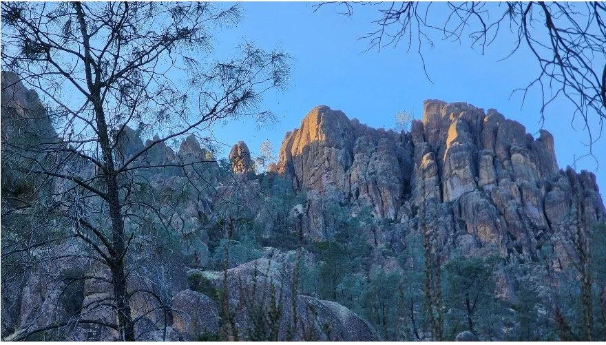
Pinnacles National Park
California is a nature-lover’s paradise boasting nine full National Parks in state and several more National Monuments, Seashores,
and Preserves along with tens of millions of acres of National Forest lands. While Yosemite National Park is by far the most
famous and popular park in the state, the nearest National Park to the San Francisco Bay Area (and one of the newest National
Parks in the system) is Pinnacles.
Located approximately 75 miles southeast of San Jose in rural San Benito County, Pinnacles features over 25,000 acres of protected
volcanic rock formations and caves which are home to multiple protected species of bats along with the endangered California Condor.
Offering more than 30 miles of hiking trails through varied and rugged terrain, the park allows visitors an opportunity to explore some
very unusual scenery.
Pinnacles features volcanic rock formations shaped by wind erosion over thousands of years along with one of the largest and most
accessible networks of talus caves in the world. Higher elevations in the park offer close encounters with condors along with multiple
lakes.
Weather in the region is highly variable and can range from the 35°F (2°C) overnight to 105°F (40°C) in the afternoon on average in
the month of June. The park does allow camping, but reservations fill up quickly well in advance. Parking is limited in the park and
lines at the entrance can range up to two hours or more on popular days and weekends.
You can access the park from the west near the town of Soledad or from the east near the town of Paicines, but no roads cross through the park. You can hike from one side of the park to the other.
Distance: 76.4 Miles, 1 hour 22 min drive (https://www.nps.gov/pinn/index.htm)

Big Sur and the Central Coast

The stretch of Pacific Coast Highway (CA-1) between Carmel by the Sea and Cambria along the central coast is one of the most
famous and photographed stretches of highway in the country. The concrete arch bridge spanning Bixby Creek north of the town
of Big Sur has appeared in countless car commercials. The stretch is dotted with nearly half a dozen state parks including Andrew
Molera, Garrapata, Julia Pfeiffer Burns and Pfieffer Big Sur. Point Lobos State Nature Preserve also sits at the north end of this
stretch, just south of the town of Carmel by the Sea.
The town of Big Sur sits inland from the high coastal bluffs that typify this stretch of highway and offers various resorts and camp-
grounds along the Big Sur River. Whether staying for the night or stopping for lunch, it’s well worth the stop to relax and cool your
feet in the river sitting in one of their iconic Adirondak chairs.
Julia Pfeiffer Burns State Park offers a short and fairly easy walk out to an overlook of McWay Cove, featuring a bird’s-eye view of
a sandy cove with McWay Falls spilling over the cliff directly onto the beach (one of the few places on the West Coast this occurs).
It is one of the most photographed coves in the country. Further south, San Simeon houses the historic and iconic Hearst Castle, the
former residence of journalism and newspaper magnate William Randolph Hearst (https://hearstcastle.org/)
Unfortunately, this stretch is prone to serious land slides that close portions of the highway nearly every winter. It is not currently
possibly to drive continuously from one end to the other due to a road closure north of San Simeon. Visitors may access Julia Pfeiffer
Burns from the north and San Simeon from the south. However, this would likely take two days with current road conditions.
Distance: Julia Pfeiffer Burns State Park – 110 Miles, 2 hour 5 min drive;
Hearst Castle – 194 Miles, 3 hours 5 min drive


Yosemite National Park
Additional Notes

Established in 1890, Yosemite National Park is the oldest and by far the most popular National Park in California and
consistently ranks in the Top 5 of National Park visitation throughout the system. On average, more than 3.5 million
people visit the park each year. Known for its sheer granite cliffs, glacially-carved monoliths, and the tallest waterfalls
in North America, Yosemite Valley is the hub of park activity. The entire park covers over 750,000 acres, but most
visitors never leave the confines of Yosemite Valley.
Yosemite offers over 800 miles of hiking trails, most of them through some very isolated and remote terrain. Yosemite
Valley is the lowest-elevation point in the park, sitting at 4000 ft (1220 m) above sea level while various trails ascend
cliffs as high as 10,000 ft (3050 m) or more. The elevation and dry air combined with significant elevation gain on most
trails makes many hikes in the park very strenuous, even for seasoned hikers.
The park features a variety of distinct areas, with the Merced River cutting through Yosemite Valley as the most
prominent and popular. Here you’ll find the most famous features like the granite monoliths El Capitan and Half Dome,
Yosemite and Bridalveil Falls, the historic Yosemite and Curry Villages, and the iconic Ahwahnee Hotel. Note that
Yosemite has implemented a timed entry reservation system daily from 0500 to 1600 during peak season in recent years,
though plans for 2025 have yet to be finalized. If you plan to visit, plan ahead and check the NPS website regularly for
updates (https://www.nps.gov/yose/index.htm). Reservations may be required to enter any portion of the park, not just
Yosemite Valley.
Beyond Yosemite Valley, the park offers a variety of other areas visitors can explore. The vast Yosemite Wilderness
offers hundreds of miles of trails through virtually untouched areas. Hikers can connect to legendary thoroughfares like
the John Muir Trail and Pacific Crest Trail (note permits may be required for PCT as well). For those looking for easier
and more accessible ways to escape the bustle of Yosemite Valley, Glacier Point Road offers driving access to a granite
outcropping at Washburn and Glacier Points that offer spectacular views of Half Dome and upper Yosemite Falls. The
town of Wawona in the southern end of the park is adjacent to the Mariposa Grove of Giant Sequoias, the largest of
several such groves in the park.
Tiago Pass Road (open summers only) takes travelers up through the higher elevations of the park, past several tranquil
alpine lakes, past Tuolumne Meadows, and eventually over Tiago Pass at the east park entrance. At nearly 10,000 ft of
elevation (3050 m), it’s the highest point in the park accessible by road. Beyond the east entrance, travelers descend rapidly
into the town of Lee Vining, which sits on the southern shore of Mono Lake in Mono County on US Highway 395. Note that
this is a seasonal road and its status depends on the snow accumulation and potential damage from the preceding winter.
It usually opens around Memorial Day, but check the park website to confirm road status before traveling.
Finally, Yosemite also includes the Hetch Hetchy Valley, which in 1923 became Hetch Hetchy Reservoir with the construction
of the O’Shaughnessy Dam on the Tuolumne River flooding the valley. The reservoir is accessible by car and open to hiking. It
features three additional seasonal waterfalls – Tueeulala, Wapama, and Rancheria. The reservoir has spurred controversy
since its conception with famed naturalist and Yosemite conservation icon John Muir (founder of the Sierra Club) being its most
famous and prominent historical detractor. The reservoir now provides drinking water to the city of San Francisco and much of
the western Bay Area including parts of San Mateo and Santa Clara Counties.
Yosemite is a true jewel of California, but it’s popularity can create challenges for visitors. If you intend to experience this
amazing place for yourself, plan ahead, obtain any necessary reservations, and anticipate delays. Try to visit on a weekday
if possible.
Distance: 195 Miles, 3 hours 56 min drive (to the Valley Welcome Center)


Sequoia and Kings Canyon National Park
Yosemite may be the most popular of California’s National Parks, but it’s not the only one situated in the Sierra Nevada mountain
range. Located around 100 miles south of Yosemite, the adjoining Kings Canyon and Sequoia National Parks offer visitors access
to even more unspoiled wilderness in the high Sierra region.
While these parks may not boast the iconic granite monoliths and stunning waterfalls of Yosemite, they do offer a much denser
concentration of Giant Sequoias and other trees like Ponderosa and Sugar Pines. In fact, the largest living thing on earth by volume
– a Giant Sequoia tree name the General Sherman Tree – calls Sequoia National Park home.
Most of Kings Canyon is accessible only by hiking trails, though the Grant Grove at the south end of the park offers a very accessible
short loop trail through an impressive grove of Giant Sequoia trees as well as a very well-appointed Visitor Center, Gift Shop, and
Café at Grant Grove Village. Traveling south along the Generals Highway, visitor enter Sequoia National Park and traverse a series
of alpine meadows and granite domes on their way to the Sherman Grove area. A nearby parking lot offers access to an information
center and shuttle stop where visitors can travel out to climb Moro Rock, a granite outcropping with a viewing platform at the top of
a winding staircase that offers sweeping view of the western range of the park and some of the peaks of the Eastern Sierra
mountains. The elevation atop Moro Rock is 6725 ft (2050 m).
The southern portion of Sequoia National Park winds visitors down through a canyon and alongside the Middle Fork Kaweah River
past Native American petroglyphs at Hospital Rock and eventually out the southern entrance and into the nearby town of Three
Rivers. Three Rivers offers a variety of lodging and dining options. The larger town of Visalia is under an hour drive. Always check
road status before visiting.
https://www.nps.gov/seki/index.htm
Distance: 205 Miles, 3 hours 38 min drive (to Grant Grove Visitor Center)


Eastern Sierra
The stretch along US Highway 395 from Carson City, NV down to Victorville, CA offers some incredibly unique and truly awe-
inspiring scenery. Quaint towns in the northern region include Bridgeport – the seat of Mono County – and Lee Vining, offering
access and views to the very unusual and oddly beautiful Mono Lake (https://www.parks.ca.gov/?page_id=514).
A 13-mile diversion off US-395 near Dog Town (the last 3 miles are unpaved) takes intrepid travelers out to Bodie State
Historic Park (https://www.parks.ca.gov/?page_id=509). Once a bustling gold mining town, Bodie was largely abandoned in the
early 1900s and now stands as one of the best remaining examples of a true gold-rush era mining town in the country. Note the
road is very rough near the park and can be treacherous in bad weather. A high clearance vehicle with four-wheel drive is
recommended, but the experience is worth it.
The June Lake Loop offers a short diversion off US-395 and sweeps drivers past several idyllic mountain lakes. Further south,
the Mammoth Lakes area offer some truly stunning scenery combined with a well-developed resort area, serving snow sport
enthusiasts in the winter and other adventurers in the summer. (https://www.visitmammoth.com/)
Continuing south, visitors encounter the towns of Bishop and Big Pine, from which they can connect to CA-166 and White
Mountain Road and climb up above 10,000 ft elevation (3050 m) to visit the Ancient Bristlecone Pine Forest. Here, for a mere
$3, visitors can walk amongst the oldest living things on earth. Some of the trees in the park have been alive 4000 years or longer.
Note that road conditions are highly variable and elevation makes hiking in this area extremely strenuous.
(https://www.fs.usda.gov/detail/inyo/specialplaces/?cid=stelprdb5129900).
The southern-most stretch of US-395 take travelers past the rugged Mt. Whitney Range in the southern Sierras. Mt. Whitney is the
highest peak in North America at 14,505 ft (4421 m). For history buffs, the Manzanar National Historic Site commemorates the
location of one of the largest Japanese internment camps during WWII. Check the site’s webpage for information on hours and
accessibility (https://www.nps.gov/manz/index.htm)
Distance: Bodie – 304 Miles, 6 hours 51 min drive; Bristlecone – 412 Miles, 8 hours 52 min drive


Southern California
Southern California offers a variety of noteworthy locations within a day’s drive of the San Francisco Bay Area. A brief summary of major areas of interest follows:
Santa Barbara – Santa Barbara sits along the southern coast roughly 30 miles northwest of Los Angeles. Home to nearly 90,000 Californians, the city boasts one of the biggest and best-preserved examples of the California Missions. With several miles of sandy beaches and bustling dining, shopping, and cultural options, Santa Barbara offers a lot of charm for a mid-sized beach town. The surrounding area houses one of the largest and most prolific wine-growing regions in the state outside Napa Valley. The nearby town of Solvang is also an interesting tourist attraction with a variety of Danish shops, food, architecture, and culture (https://solvangusa.com/).
Los Angeles – Los Angeles is the largest city, metropolitan area, and county in the state, and one of the largest in the country. Over 3.8 million Californians (roughly 10% of the state population) live within the city limits. LA is famous for many things, most notably being the world leader in producing films and television shows. Nearly every major network and production studio has facilities in and around the county (mainly in Burbank and Studio City) and some are headquartered there. The city is also home to other famous places like Grauman’s Chinese Theater, the Hollywood Walk of Fame, and the Hollywood sign. The city of Anaheim in neighboring Orange County is home to several renowned theme parks including Disneyland, and Knott’s Berry Farm.
https://www.discoverlosangeles.com/
San Diego – The city of San Diego sits at the far southern end of the California coast on the border with Mexico. It is home to over 1.3 million Californians, the second-largest city in the state behind Los Angeles. San Diego offers big-city amenities with a slower-paced beach-town feel along with world-class beaches, surfing, and scenery. Enjoy a stroll and a meal in the historic Gas Lamp Quarter or Balboa Park, tour through one of San Diego’s many museums or its famous zoo, enjoy a day at the beach, explore the historic Hotel del Coranado, or travel up to Cabrillo National Monument for a stunning view of San Diego’s harbor and skyline with views well into Baja Mexico on a clear day.
https://www.sandiego.org/explore.aspx
National Parks – Southern California houses several National Parks including Death Valley (one of the lowest-elevation and hottest places on earth), Joshua Tree, and the Channel Islands. The desert parks are extremely hot in summer and Channel Islands requires advanced reservations. Plan accordingly.
Distance: Santa Barabara – 278 Miles, 4 hours 35 min drive; Los Angeles – 339 Miles, 5 hours 37 min drive; San Diego – 459 Miles, 7 hours, 24 min drive
If you intend to explore more of our state, the following information may be helpful.
Expect to encounter significant traffic especially around major cities that could affect projected drive times. Road work and construction are also common especially in the summer and this may force you to consider an alternate route.
Book accommodations in advance where possible. Most of the suggestions in this guide are quite popular and draw large crowds, especially in the summer when schools are out. Hotels and other accommodations in the vicinity may fill up quickly. Always plan and check in advance.
You may encounter snow and road closures into early June due to snow and winter road damage. Some roads in California require drivers to carry tire chains and/or have a four-wheel drive vehicle under certain conditions. The California Department of Transportation (CalTrans) website is an excellent resource for information on road conditions. https://roads.dot.ca.gov/
Usage fees for parks and protected spaces vary. Most California State Parks charge $10 per vehicle for day use entry, though some (like Bodie State Historic Park) charge admission per person. National Parks range from free entry to $40 per vehicle. Entry passes are generally good for five days from purchase. Note that Yosemite may implement reservation requirements to enter the park between 0500 and 1600 daily during the summer. If you intend to visit multiple sites in the NPS system, you can obtain an annual America the Beautiful Pass for $80. This grants admission to all National Parks, Monuments, Historic Parks, and Preservers for one year. Reservations are still required for applicable parks whether you are a pass holder or not. The California State Park system offers a similar annual pass (called the Golden Poppy Pass) for $125, though there are more restrictions on its use.
Plan your route. Beyond road conditions and traffic, note that many of the National Parks and other wild spaces described here reside in very remote and rural parts of California, far from any developed towns and cities. You may encounter stretches where you travel 100 miles or more at a time without encountering any services. Plan accordingly.
Weather in California can be unpredictable, especially on the coast. California is notorious for “microclimates;” many long-time residents joke, “if you don’t like the weather, get in your car and drive five minutes.” It’s very common in the summer for inland areas like San Jose to reach over 90°F (32°C) while just 35 miles away in Santa Cruz it could be under 60°F (15.5°C). Warm weather inland tends to draw in marine moisture on the coast, meaning a hot day in San Jose often means a foggy evening in Santa Cruz. Weather at higher elevations can be even more unpredictable and sudden thunderstorms are common in the Sierras in the summer. It’s important to dress for a wide range of conditions, bring layers, and be prepared for anything.